
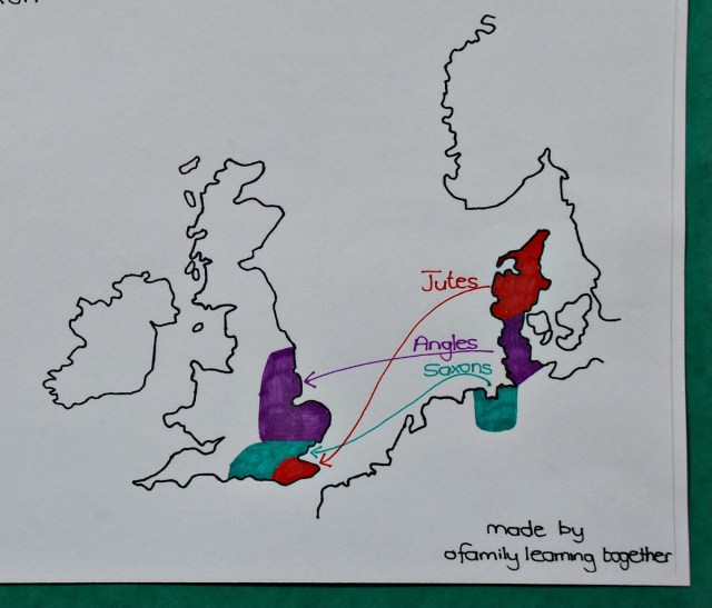
We are started reading some Anglo-Saxon Factual Fiction Books. We are loving them but both my kids started getting a bit confused by the different characters and where they came from (something that is very important for my son to understand or he gets frustrated with the stories). So we started looking at where the Jutes, Saxons and Angles originally came from and which areas they settled in. While we were doing this my daughter decided it would be good to have a map showing all of this so we created one – nothing fancy – just hand-drawn but it clearly shows the different groups, the areas they came from and where the initially settled.
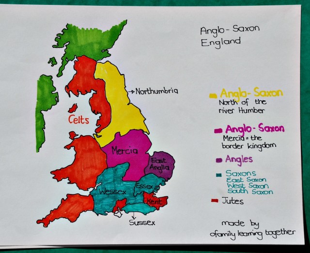
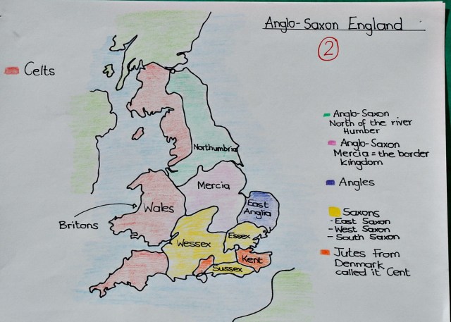
Then we got onto how they started dispersing, pushing the Celts back and forming their own territories / kingdoms, so again we decided a map was needed and we came up with this one – also a hand-drawn map (we actually have 2 different versions of this one).
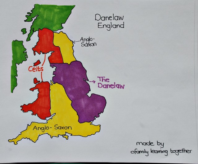
That was really where our factual fiction books stopped with the different Anglo-Saxons kingdoms but of course we had started researching this so we continued and read up about Danelaw – and you guessed it required a third map.
We are actually creating a Anglo-Saxon board in our lounge area just because that is where we tend to sit when we read our books. And even though the maps are created by my daughter and myself and are hand drawn I must admit it is helpful having them up as the kids can keep referring back to them.
I am going to leave the PDF files with the maps here in case anyone else wants a visual reminder.
Anglo-Saxon England map showing where the Jutes, Saxons and Angles came from
Map of the Anglo-Saxon England Kingdoms
2nd map of Anglo-Saxon England
Map of Anglo-Saxon England showing the Danelaw.
Also we created blank maps because my daughter wanted to “test” herself and see if she could remember everything so I am attaching the PDF of those blank map templates aswell.
They are NOT fancy and are Hand-drawn but I know sometimes it can get frustrating when you are looking for a FREE download for home education and you can’t find anything.
Blank Anglo-Saxon Migration (1)
Blank Map of the Anglo-Saxon Kingdoms
Blank map of the Anglo-Saxon Danelaw
If you are busy learning about the Anglo-Saxons you might enjoy these books – Shield Maiden and the First King of England


These are great! Thank you for putting them on your blog – we are studying the Anglo-Saxons right now. They are very neat maps!
LikeLiked by 1 person
We definately found seeing the areas plotted out on maps helped to explain how it all progressed
LikeLike
What a great idea! Your maps are fantastic!
LikeLiked by 1 person
Thanks.
LikeLiked by 1 person
What a great way to combine learning about history and geography.
LikeLiked by 1 person
Thank you. It has been fasinating as you can see how the different areas of England were being formed even way back then
LikeLiked by 1 person
Hi I am 68 years old and have started researching English history just for fun. Looking for maps online that would help me make sense of the timeline, I came across your site. So simple, beautifully done! thank you 🙂
LikeLiked by 1 person
Thank you so much for dropping me a note and letting me know that you like the maps
LikeLike
Hi, “Jute” here. Great job!
Yesterday, I learned a new thing detail though. Something that made it more logical to me to understand how they came from my area as Jutes and Angles.
Where the crossing over the channel is, the Jutes settled. But geographically the Jutes would have come from further away than the Angles and the Saxons.
Normally when a movement starts, the nearest settles first.
I saw an explanation: actually the Jutes who settled, were probably Jutes who had already earlier on made a move south, passed the Angles and Saxons and settled along the now Dutch northern coast.
So they were the closest to “England” when the next movement started. They arrived and settled. The Saxons then settled behind finding the next free areas and then the Angles, passing the Jutes and Saxons, ended further North.
To me it is not about, who came first as I live in the part of “now Jutland” that was the area of the Angles back then. Am just generally interested in how the movements of peoples happened through history all over the world.
Here’s the link if you are interested, a 5 minutes video: https://www.youtube.com/watch?v=ZwBGMeuxtyw&t=56s
Greetings from Denmark
LikeLike